

Meall an Tagraidh [Meall an t-Sagairt]
Good walks are even better shared.
NN1994 : Summit cairn, Meall an Tagraidh
Richard Law Photo source
Overview
Meall an Tagraidh [Meall an t-Sagairt]
Overview
Nestled in the heart of the Scottish Highlands, Meall an Tagraidh rises to a proud elevation of 819 meters. A true Munro, this mountain offers thrilling hikes paired with captivating views.
Geology
With a primary composition of granite, Meall an Tagraidh showcases a rich geological tapestry, shaped by ancient glaciers that carved out its rugged forms. The rocks are a testament to millennia of natural evolution, providing a unique insight for geology enthusiasts and curious hikers alike.
Routes
East Ridge Route
This popular route begins at the nearby parking area and is known for its moderate elevation gain and well-defined paths. As you ascend, you’ll be treated to stunning views of the glen, making it perfect for a leisurely hike.
West Route from Strath Fillan
If you’re looking for a bit more adventure, the route from Strath Fillan presents a challenging trek with rougher terrain. Be prepared for a workout and ensure you check the weather before heading out!
Summit Features
At the peak, adventurers will find a traditional cairn—a perfect spot for a summit photo and a chance to catch your breath while soaking in the panoramic vistas. Bring your best camera; you'll want to remember this!
Terrain
Expect a varied landscape, where grassy slopes meet rocky paths. Some areas can become boggy after rain, so sturdy footwear is essential. It’s always good to have a bit of grit when hiking in the Highlands!
Views
From the summit, the highlights include captivating glimpses of the Trossachs and Loch Lomond, along with the majestic Ben Lomond. Late spring to autumn tends to offer the clearest views—they really do set the stage for a postcard-perfect experience.
Hazards
While the trails are generally well-marked, sudden weather changes can pose challenges. Loose rocks are another hazard to watch out for, so pick your path carefully!
Access
Nearest Parking
Park at the small car park near Crianlarich, and you're just a stone's throw away from the trails.
Public Transport
Crianlarich is accessible via rail and local buses, making it fairly easy to reach for those travelling without a car.
Nearest Town
Crianlarich also serves as a quaint base, offering some facilities and a warm welcome to weary hikers.
Facilities
While the facilities near the mountain are limited, community spirit thrives in Crianlarich. Look for local cafes and guesthouses to recharge after your hikes.
History
Name Meaning
The mountain's name translates to 'Hill of the Curious', a fitting title for those drawn to explore its heights.
Significance
Historically, this area has been vital as traditional hunting grounds. Its rugged beauty continues to inspire those who tread its paths.
In conclusion, Meall an Tagraidh is a delightful gem in the Scottish Highlands, suitable for those looking to experience the thrill of climbing a Munro without the fierce intensity often associated with other high peaks. Lace up your hiking boots and set out to embrace the wonders that await!
Explore routes near Meall an Tagraidh [Meall an t-Sagairt]
Walks starting near this hill. Open a route to check its map, distance and full itinerary.
Banavie to Glen Loy Aqueduct: Neptune’s Staircase Canal Towpath
View route
Ben Nevis via Mountain Path
View route
Fort Augustus to Kytra Lock: Caledonian Canal Towpath
View route
Great Glen Way low route: Fort Augustus to Invermoriston Old Bridge
View route
Route planning notes
These notes describe possible approaches. Check a route's map and access information when planning your walk.
East Ridge Route
A scenic route starting from the car park at the nearby glen, this trail winds gently up the east ridge offering breathtaking views earlier on.
West Route from Strath Fillan
Beginning at Strath Fillan, this route traverses more rugged terrain and should not be attempted in adverse weather conditions.
Make a day of it, together
Find someone to share the walk with, or organise a day out along a route you like.
Photo Gallery
View all Photo could not load
NN1994 : Summit cairn, Meall an Tagraidh
Richard Law
Hill facts and local notes
Classifications
Elevation
760m
2,493 ft
Prominence
134m
Coordinates
57.0022, -4.9742
NN194940
OS Map
34
Explorer: 399 400
At the Summit
The summit is marked by a traditional cairn, which offers a perfect spot for photographs along with panoramic views of the surrounding ranges.
Terrain & Geology
The mountain is primarily composed of granite with dramatic glacial features, which provide fascinating insights into the earth's geological history.
Views & Scenery
From the summit, hikers can gaze across the expansive vistas of the Trossachs and the Loch Lomond area, with Ben Lomond visible on clear days.
History & Heritage
Name Origin
The name 'Meall an Tagraidh' translates roughly to 'Hill of the Curious', fitting for a mountain that prompts exploration.
Historical Significance
This area boasts historical significance as part of ancient hunting grounds, cherished by the local clans.
Getting There & Facilities
Parking
The nearest parking is available at the end of the minor road leading from Crianlarich; a small car park exists at NN183926.
Public Transport
Crianlarich is well served by rail services, making it accessible from various locations. Local buses also connect to surrounding areas.
Nearby Facilities
There are few facilities directly at the base; however, Crianlarich offers several guesthouses, cafes, and basic amenities like toilets.
Safety Information
Known Hazards
- Be cautious of sudden weather changes, as conditions can vary quickly in the Highlands. Loose rocks on the paths can be treacherous.
General Safety Tips
- Check weather conditions before setting out
- Carry appropriate clothing and equipment
- Let someone know your planned route
- Take a map, compass, and GPS device
- Carry emergency supplies: food, water, first aid kit, torch
Hills
Some common questions about the hills answered
Are there group walks up Meall an Tagraidh [Meall an t-Sagairt]?
Many walkers use Walkmates to join or organise walks with others. You can check for group walks around Meall an Tagraidh [Meall an t-Sagairt] through the maps
Are there other walkers around Meall an Tagraidh [Meall an t-Sagairt]?
Activity varies by location and time, but Walkmates lets you see whether others have shared walks or shown interest in this area. Find other people through the walking friends search walking friends for Meall an Tagraidh [Meall an t-Sagairt] search or of course create your own walk for Meall an Tagraidh [Meall an t-Sagairt]
Can I organise a walk to Meall an Tagraidh [Meall an t-Sagairt]?
Yes. If there aren’t any walks listed already, you can create a walk and make it available for others to join.
If you're signed up to Walkmates, you can create a walk to Meall an Tagraidh [Meall an t-Sagairt].
How do I find a walk up this hill?
There are often multiple ways to walk this hill, depending on experience and route preference. Walkmates helps you explore walks and routes that others have shared.
Can I suggest a new route up Meall an Tagraidh [Meall an t-Sagairt]?
Yes. You can suggest or create routes to share with others. Walkmates focuses on the social side of walking, so routes are used to help people organise walks and explore areas together, rather than as detailed navigation tools or route libraries.
Other uses really appreciate knowledgeable walkers sharing their routes. Share your favourite route to Meall an Tagraidh [Meall an t-Sagairt] here
The is an error or something incorrect about this hill. How do I let you know?
We always strive to keep the information on Walkmates as accurate as possible. If you find an error, please let us know through the contact form and we'll aim to correct it as quickly as possible
Community Discussion
Comments
Location
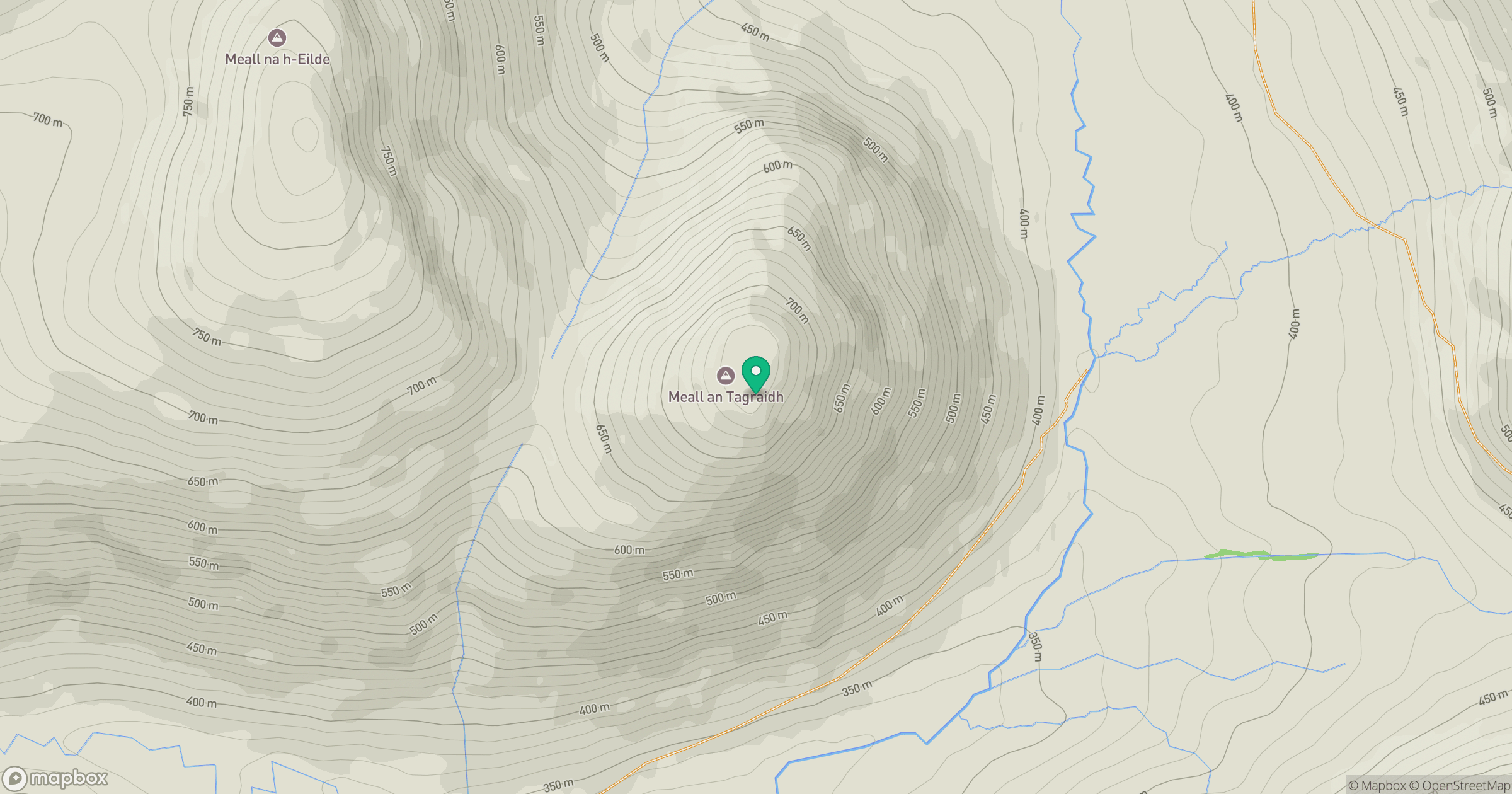
Grid reference: NN194940
View on OpenStreetMapOpens a map in a new tab, centred on the hill.
Nearby Hills
Aonach Mor
1,220m
Carn Mor Dearg
1,221m
Aonach Beag
1,234m

Ben Nevis [Beinn Nibheis]
1,345m
Stob Choire Claurigh
1,177m
No comments yet. Be the first.